Ski bunnies preparing to don their mittens had better be quick: despite a return to winter this week, a scorcher is heading for Victoria.
Sunday night’s cold front has caused an overnight dusting of snow across the Alpine region, Mount William and the Grampians, temporarily extending the snow season until the end of the week.
The Bureau of Meteorology’s senior forecaster Phil King said rain and temperatures of -3 in some Alpine areas caused an unusual touch of snow for this time of year.
“Falls probably got about 10 centimetres of snow up there – they had 10 millimetres of rain,” Mr King said.
He said that spring was the most volatile time of the year — especially in Victoria — and that as “soon as the winds come in from the north and [combine with] the longer days and heated interior, we can quickly get temperatures racing above 30 degrees”.
“That’s what spring’s about – a belt of cold weather coming in from the south to remind us that winter is not quite over,” Mr King said.
On Tuesday morning, VicRoads warned drivers travelling on the Great Alpine Road to beware of high winds and snow between Harrietville and Dinner Plain.
“Multiple trees have fallen on the road .. and snow clearing operations have been mobilised,” VicRoads posted on its website.
Cold conditions are set to continue until Thursday, Mr King said, with more snow likely to fall in the Apline region.
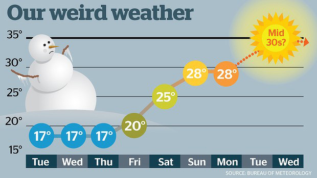
But from Friday, Melburnians can look forward to a balmy weekend — 25 degrees on Saturday, and 28 on Sunday — with the mercury hovering at 28 on Monday and Tuesday.
Mr King said temperatures could reach as high as the mid-30s by Wednesday week, and that some parts of north-western Victoria could see temperatures soar into the 40s next week as a hot change moves across the state.
“There could be a 40-degree day in the Malee and Wimmera region — so around Mildura — next week,” he said.
This story first appeared in The Age


