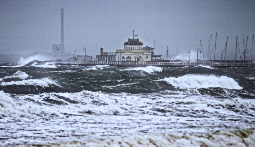
UPDATE: Victorians – thousands still without power – are mopping up after an icy, cyclone-like storm thrashed the state, causing transport chaos, mass blackouts and a storm surge that broke the Yarra River’s banks.
NASA satellite images show an intense, churning cold front that brought driving rain, freezing wind blasts and heavy snow across the state’s peaks. Falling trees and flying debris cut roads and rail lines, and about 60,000 homes and businesses lost power.
While conditions have eased, the weather bureau forecast rain and wind to to increase again on Wednesday night, with another strong cold front on the way.
On Tuesday, dangerous weather lashed the state, leaving people injured, trains lines suspended, homes without power, roads closed and temperatures plummeting below freezing with wind chill.
The Yarra burst its banks in several places on its route through the CBD in the early afternoon, flooding the Queen Street Bridge and popular bar Ponyfish Island.
Victorian power companies worked frantically overnight trying to restore power to more than 60,000 homes across the state.
MEGA GALLERY: Wild weather hits Melbourne and beyond
CitiPower and Powercor spokesman Drew Douglas said at 7.30am about 1400 homes were still without power, mainly in the Otways, Bacchus Marsh, Terang and Camperdown areas.
Mr Douglas said crews aimed to get residents back on the grid by midday.
SP AusNet spokesman Jonathon Geddes said 7000 customers were still without power on Wednesday morning, down from 24,000 on Tuesday.
He said Toolangi and Kinglake were the areas most affected by wild winds, with fallen trees and branches snaring lines and snapping power poles.
State Emergency Services received more than 3000 calls for assistance on Tuesday, with a further 200 from midnight on Wednesday.
SES spokesman Stefan Delatovic said it was “surprising” how many help calls related to “trampolines being turned into missiles”.
“This includes a trampoline flying into a neighbour’s house and smashing the windows, as well as cars being hit by flying trampolines.
The SES also attended to trees falling on cars, a collapsed wall, and garden sheds being blown into people’s yards.
“But today looks like it’s just going to be about tidying about from yesterday,” Mr Delatovic said.
The Bureau of Meteorology has downgraded its severe weather warning across the state, but will continue to monitor weather conditions and issue warnings if necessary.
Duty Forecaster Michael Efron said Wednesday will be a much calmer day, with wind gusts expected to peak at 60 to 70km/h and a top of 16 degrees.
He said despite some wind sweeping the state early on Wednesday morning, “we don’t see anything as strong as during Tuesday”.
“The highest gusts overnight were in the range of 70 to 80km/h.
“Those winds were at Point Wilson, where it reached 80 km/h, 78 km/h at Essendon Airport and 70 km/h in St Kilda.”
Showers will increase in the Melbourne area from 8pm, Mr Efron said, and winds will peak at 60 km/h.
“The winds will pick up compared to this morning, but they will not be as strong as yesterday’s, which will be the strongest we will see over the course of the week.”
But Mr Efron warned Victorians were not free of the cold snap, with very low temperatures expected for the weekend.
“Although Thursday looks relatively dry and in between cold fronts, there looks to be another strong system which will reach the west of the state during Friday evening, and then move across central Victoria during Saturday,” he said.
“Saturday and Sunday will see a strong cold front, and we could also see hail in southern Victoria”.
Melbourne saw about 5 millimetres of rainfall on Tuesday and overnight, with eastern suburbs suffering the worst of the freezing rain, where 10 to 25mm fell.
“It is typical in this sort of pattern to see the eastern suburbs receive sometimes double, or even triple, that of the western and northern suburbs,” Mr Efron said.
“The influence of Port Phillip Bay combined with southwesterly winds tends to result in an increase in rainfall across those suburbs.”
But the cold snap was good news at least for the state’s snowfields, where 40 centimetres of snow fell at Mount Buller, and more than 50cm at Mount Hotham in a 24-hour period.
Mr Efron said a further 1 metre of snow was expected to fall by the weekend.