Why were Monday’s storms so dramatic?
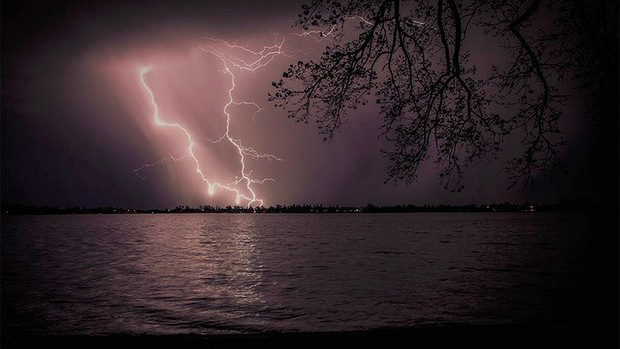
The amount of lightning produced during Monday’s storms, and the frequency of the lightning strikes was highly unusual. Unfortunately, the Bureau of Meteorology is unable to forecast the frequency or intensity of lightning during any given storm.
However the Bureau does forecast thunderstorms, which are always accompanied by lightning. If these storms are expected to produce large hail, damaging winds, tornadoes or heavy rainfall that may lead to flash flooding, the Bureau issues severe thunderstorm warnings.
Monday’s storms were also unusual in that they were associated with a mid-level trough moving through the state, as opposed to a standard storm, which is caused by surface troughs, helped along by the still lingering daytime heat. A trough – an area of instability in the atmosphere where air masses clash, producing different levels of pressure and wind types – can occur across three levels: surface or ground level, which is where most storms form; mid-level, the layer above the surface, and the upper-level trough, far up in the atmosphere.
Is it unusual to have a storm in the middle of the night?
Yes. Most storms occur between midday and 9pm, when surface temperatures are the warmest, which makes the atmosphere the most unstable. This is why thunderstorms usually form in the tropics: the moist and warm weather create the perfect conditions of thunder and lightning.
How much lightning was there?
Lightning strikes are recorded via a network of lightning detectors, which are placed on buildings or ground level. From 6pm on Sunday, about 5000 to 6000 lightning strikes were recorded in and around the Melbourne region, occurring most often in Melbourne’s CBD and the eastern suburbs.
Across Victoria, company Global Position and Tracking Systems (GPATS) measured almost 40,000 strikes from 5pm Sunday to 10am on Monday.
Are lightning strikes dangerous?
Potentially. There are two types of lightning strikes: cloud-to-ground and cloud-to-cloud. Meteorologists usually display cloud-to-ground strikes on their radars, which are noisier and more life-threatening because they can hit the ground. “Those are the strikes that cause fire and blackouts,” explains Benjamin McBurney, meteorologist for Weatherzone (owned by Fairfax).
On Monday, Melbourne was hit by a devastating combination of lightning strikes and power blackouts, which caused the train network to fail for hours after signalling equipment was damaged by lightning. A Prahran family were lucky to escape after lightning struck a nearby tree, causing it to fall on their home as it burst into flames, while trees near the Kew cemetery also caught on fire.
Could people have been killed?
Despite the massive amount of lighting strikes occurring overnight, the probability of being hit by lightning is extremely small. Forecaster Chris Godfred says 40,000 lightning strikes across Victoria may be a big number on paper, but “when you look at it on the ground, it doesn’t translate into massive strikes”.
“You might see large number of lightning strikes across an area, but when you drill down to a particular point at a particular moment, that doesn’t necessary mean you’ll be seeing a lot of strikes happening in that moment,” he says.
So, although there is always a risk and danger associated with lighting, it is highly unlikely anyone would be hit if they took proper precautions, such as staying inside, keeping away from windows and doors, unplugging appliances and avoiding being near water.
Where did the storm come from?
The storm originated in South Australia, where it began before crossing the border of western Victoria about 6pm on Sunday. It then continued to brew in Victoria’s north-west before moving into western and central Victoria about 9pm. During the night, the storms continued to move east through central Victoria, finally reaching Melbourne city about 2 am on Monday, and took an hour to pass through. The Bureau’s forecaster Steven McGibbony said the second storm bout began about 6am on Monday, lasting a few hours before easing into heavy showers.
Was there much rain?
In a nutshell, yes. Melbourne experienced its wettest 24 hours this year after rain bucketed down on the city from 2am. Mr McBurney says 5 millimetres of rain fell on the city in less than 10 minutes during the first storm bout, followed by another 25mm from 6am.
“In terms of the Melbourne area in October, the average is 66mm – and we’ve had a third of that in 24 hours,” Mr McBurney said.
The torrents of rain caused flash flooding in some areas of Melbourne, with Docklands submerged for hours while train tracks on the Sandringham line, near Prahran, were also underwater.

